Template:OoTNavMap: Difference between revisions
Jump to navigation
Jump to search
PhantomCaleb (talk | contribs) (From the Places in OOT NavMap. Thanks, Dany!) |
PhantomCaleb (talk | contribs) mNo edit summary |
||
| Line 22: | Line 22: | ||
rect 1 58 45 111 [[Desert Colossus]] | rect 1 58 45 111 [[Desert Colossus]] | ||
rect 263 76 303 100 [[Kakariko Village]] | rect 263 76 303 100 [[Kakariko Village]] | ||
rect 305 72 340 98 [[Kakariko Graveyard]] | rect 305 72 340 98 [[Kakariko Village Graveyard|Kakariko Graveyard]] | ||
rect 267 26 302 50 [[Death Mountain]] | rect 267 26 302 50 [[Death Mountain]] | ||
rect 242 33 269 55 [[Goron City]] | rect 242 33 269 55 [[Goron City]] | ||
rect 254 45 290 78 [[Death Mountain Trail]] | rect 254 45 290 78 [[Death Mountain#Death Mountain Trail|Death Mountain Trail]] | ||
poly 298 115 308 108 322 101 340 101 356 102 363 97 378 100 360 111 348 110 335 110 319 116 310 118 [[Zora's River]] | poly 298 115 308 108 322 101 340 101 356 102 363 97 378 100 360 111 348 110 335 110 319 116 310 118 [[Zora's River]] | ||
rect 387 86 417 111 [[Zora's Domain]] | rect 387 86 417 111 [[Zora's Domain]] | ||
Revision as of 20:14, 19 April 2011
| Regions in Ocarina of Time | |
|---|---|
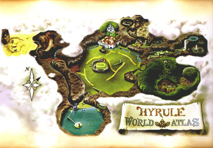 Click on a location | |
Explanation
This template provides an easy way to navigate Hyrule in Ocarina of Time.
Usage
To use this template, type:
{{OoTNavMap}}