File:Tetra's Cabin Map.png
Jump to navigation
Jump to search

No higher resolution available.
Tetra's_Cabin_Map.png (256 × 256 pixels, file size: 82 KB, MIME type: image/png)
Summary
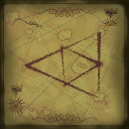
| Summary | A map found hanging in Tetra's cabin from The Wind Waker. The map shows the Pearl Islands (Dragon Roost Island, Forest Haven and Greatfish Isle) connected by lines to form the outer triangle. The three Triangle Islands are connected, forming the inner triangle. Overall, they create a Triforce around the Tower of the Gods. |
|---|---|
| Type | Texture |
| Source | This file lacks a source, please contact the original submitter and add it, or upload a new version of this file. |
| Game | |
| Licensing | 
|
File history
Click on a date/time to view the file as it appeared at that time.
| Date/Time | Thumbnail | Dimensions | User | Comment | |
|---|---|---|---|---|---|
| current | 20:30, 19 June 2010 | | 256 × 256 (82 KB) | Abdullah5599@legacy41961806 (talk | contribs) | A map found hanging in Tetra's cabin from the Wind Waker. |
You cannot overwrite this file.
File usage
The following 2 pages use this file: