Atlas of Koholint Island
Jump to navigation
Jump to search
The Atlas of Koholint Island is an object in Link's Awakening.[1][note 1]
Location and Uses
The Atlas of Koholint Island is located in the Village Library. It allows Link to see the map of Koholint Island in its entirety rather than seeing only places he has already discovered.
Nomenclature
| Language | Name | Meaning | |
|---|---|---|---|
| FrenchCA | Atlas de Cocolint | Koholint Atlas | |
Gallery
-
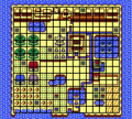
The content of the Atlas of Koholint Island

See Also
Notes
- ↑ This object is also referred to as the Island Map in The Legend of Zelda: Link's Awakening—Nintendo Player's Guide by Nintendo of America.[2] However, as the in-game term takes precedence, this term is not considered Canon.
References
- ↑ "'Atlas Of Koholint Island' You can move the cursor and look up the name of a place..." — Atlas of Koholint Island (Link's Awakening DX)
- ↑ The Legend of Zelda: Link's Awakening—Nintendo Player's Guide, Nintendo of America, pg. 12