Gerudo Highlands: Difference between revisions
(Added climate data) |
(Added climate prose) |
||
| Line 28: | Line 28: | ||
====Climates==== | ====Climates==== | ||
The {{Term|BotW|Gerudo Highlands}} contain two distinct climates, "Gerudo frost" and "Gerudo plateau." The two climates are unique to the {{Term|BotW|Gerudo Highlands}}, and do not appear in other map areas. | |||
The Gerudo frost climate is split into two sub-areas. The northern portion spans from {{Term|BotW|Mount Agaat|link}} to {{Term|BotW|Zirco Mesa|link}}, with the middle bounded by the {{Term|BotW|Cliffs of Ruvara|link}} and {{Term|BotW|Birida Lookout|link}}. The canyon housing the {{Term|BotW|Yiga Clan Hideout|link}} forms a noticeable intrusion into the area. | |||
The southern portion of the Gerudo frost climate surrounds {{Term|BotW|Mount Granajh|link}} and {{Term|BotW|Daval Peak|link}}. Comparatively, it has a noticeable lack of {{Plural|BotW|Wildberry|link}} and cutting {{Term|BotW|Grass|link}} can spawn {{Plural|BotW|Hot-Footed Frog|link}} instead of {{Plural|BotW|Restless Cricket|link}}. | |||
The Gerudo plateau climate is a dominant, contiguous climate. In the north, the area surrounds the base of {{Term|BotW|Mount Agaat}} and is split by the Gerudo frost climate. It stretches southeast to the {{Term|BotW|Oseira Plains|link}} and {{Term|BotW|Nautelle Wetlands|link}}. | |||
{{Collapsible | {{Collapsible | ||
|header= Gerudo Frost Climate | |header= Gerudo Frost Climate | ||
Revision as of 00:52, 30 April 2023
The Gerudo Highlands is a mountainous area in the Gerudo Region in The Legend of Zelda series.[1][2]
Features and Overview
Breath of the Wild
The Gerudo Highlands surround the Gerudo Desert and isolate the area from the rest of Hyrule Kingdom. Its cliffs sit to the east of the Desert and its tall, snowy mountains overlook the Desert to the north. Link needs protection from the cold to navigate the northern and southeastern Highlands unharmed. Gerudo Highlands is the location where the ancient Sheikah technology was first uncovered.[3] Nine Stone Taluses can be found throughout the Highlands.
Climates
The Gerudo Highlands contain two distinct climates, "Gerudo frost" and "Gerudo plateau." The two climates are unique to the Gerudo Highlands, and do not appear in other map areas.
The Gerudo frost climate is split into two sub-areas. The northern portion spans from Mount Agaat to Zirco Mesa, with the middle bounded by the Cliffs of Ruvara and Birida Lookout. The canyon housing the Yiga Clan Hideout forms a noticeable intrusion into the area.
The southern portion of the Gerudo frost climate surrounds Mount Granajh and Daval Peak. Comparatively, it has a noticeable lack of Wildberries and cutting Grass can spawn Hot-Footed Frogs instead of Restless Crickets.
The Gerudo plateau climate is a dominant, contiguous climate. In the north, the area surrounds the base of Mount Agaat and is split by the Gerudo frost climate. It stretches southeast to the Oseira Plains and Nautelle Wetlands.
| Climate Data | |||||||||||||||||||||||||||||||||||||
|---|---|---|---|---|---|---|---|---|---|---|---|---|---|---|---|---|---|---|---|---|---|---|---|---|---|---|---|---|---|---|---|---|---|---|---|---|---|
 |
| ||||||||||||||||||||||||||||||||||||
| |||||||||||||||||||||||||||||||||||||
| Climate Data | |||||||||||||||||||||||||||||||||||||
|---|---|---|---|---|---|---|---|---|---|---|---|---|---|---|---|---|---|---|---|---|---|---|---|---|---|---|---|---|---|---|---|---|---|---|---|---|---|
 |
| ||||||||||||||||||||||||||||||||||||
| |||||||||||||||||||||||||||||||||||||
Areas


Other Appearances
Hyrule Warriors: Age of Calamity
Nomenclature
| Language | Names | Meanings |
|---|---|---|
Japanese | ゲルドこうち高地 (TotK) | |
ChineseTR | 格魯德高地 (Gélǔdé Gāodì) (TotK) | |
ChineseSI | 格鲁德高地 (Gélǔdé Gāodì) (TotK) | |
Dutch | Gerudo-gebergte (HWAoC)[5] | Gerudo Mountain Range |
FrenchEU | Hauteurs Gerudos (TotK) | |
FrenchCA | Hauteurs Gerudos (TotK) | |
German | Gerudo-Hochebene (TotK | HWAoC)[4] | |
Italian | Grande altopiano Gerudo (TotK) | |
Korean | 겔드 고지 (TotK) | |
SpanishEU | Cordillera de Gerudo (TotK) | |
| This table was generated using translation pages. To request an addition, please contact a staff member with a reference. | ||
Gallery
-
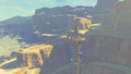
The Gerudo Tower overlooking Gerudo Highlands
-
The Statue of the Eighth Heroine
-
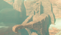
Link standing in front of Birida Lookout
-
Link overlooking Taafei Hill
-
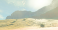
The Gerudo Canyon Pass
References
- ↑ "Gerudo Highlands" — Map (Breath of the Wild)
- ↑ "Gerudo Highlands" — Map (Hyrule Warriors: Age of Calamity)
- ↑ "We decided to heed the prophecy and began excavating large areas of land. It wasn't long before we discovered several ancient relics made by the hands of our distant ancestors." — King Rhoam (Breath of the Wild)
- ↑ "Gerudo-Hochebene" — Map (Hyrule Warriors: Age of Calamity)
- ↑ "Gerudo-gebergte" — Map (Hyrule Warriors: Age of Calamity)